Cool Walks aims to help pedestrians avoid dangerous heat and find public drinking fountains.
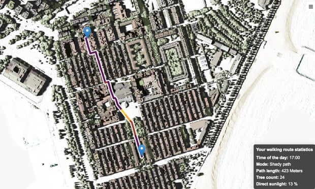
Cool Walks, a routing tool for pedestrians first developed at a data visualisation contest, aims to show users a variety of walking routes to take for their intended destinations.
Users can choose the most direct route, a shady route that may take a little longer, or they can set the app to “vampire mode”, which avoids direct sunlight at all costs. Users can also use the app to find drinking fountains, or places to shelter from the sun.
The app uses a tool called Lidar to create high-resolution models of ground elevation, accurate to within 10cm. This information is combined with data on the sun’s path to work out where is in shade at any given time of day.
Barcelona is looking to use green spaces and trees as part of its efforts to mitigate the effects of global heating. The city’s 20-year tree masterplan aims to increase the proportion of land covered by trees from 25% to 30%.
Albert Carbonell, lead analyst at the geographic information systems department at urban planning agency Barcelona Regional and one of the developers of the app, said: “I don’t know many cities that deal with pedestrian routing. It’s nice for a public agency to work with data that the city gave to us, to demonstrate that it’s feasible to come up with technological solutions to climate change”.
Source: www.theguardian.com